Townships, Ranges, and Sections
An Overview
An Overview
|
|
Gila and Salt River Meridian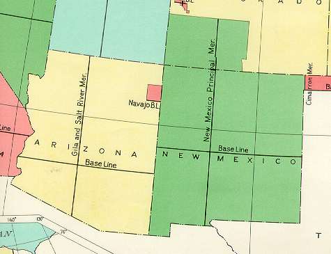 |
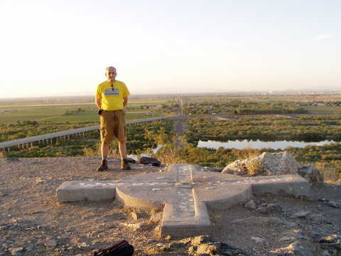 Arizona's "Initial Point" The United States Public Land Survey (USPLS) began in 1785 with the Land Ordinance. The USPLS effort was dedicated to surveying public lands that were unsettled at that time. An initial point was first selected, and then a North-South line was drawn through the initial point, and given a name. This North-South line is called a meridian. An East-West line is also drawn through the "initial point", and this line is called a base line. The photo above shows me standing right next to Arizona's "initial point". In the above photo, the baseline goes into the horizon, and the meridian is going across the photo. Notice the road in the distance. The center line of that road lines up with the baseline. The road is very appropriately named "Baseline Road". The photo below is a closeup of the "initial point" (it is located in the middle of the cross, above). All land ownership, as well as all political boundaries in Arizona, are based on this point. The map at the top left shows the "Gila and Salt River Meridian", and associated base line. From these two lines, the townships and ranges are defined. Townships are stripes, six miles wide, running in an East-West direction, parallel to the baseline. Ranges are also stripes, six miles wide, running in a North-South direction, parellel to the meridian. The map of Apache County (note: Apache County is located in the North-East corner of Arizona), on the bottom left, has the townships and the ranges shown. Note that the townships and ranges, taken together, define a grid of six mile by six mile squares, based on the meridian and the base line. The townships are numbered according to their distance from the base line, and according to whether they lie North or South of the base line. So, for example, township 13N is the thirteenth township North of the base line (it lies 13 * 6miles = 78miles North of the base line). Ranges are numbered according to their distance from the meridian, and according to whether they lie East or West of the meridian. For example, range 29E is the 29th range East of the meridian (it lies 29 * 6miles = 174miles East of the meridian). As mentioned above, the townships and ranges divide the land into six mile by six mile squares. Each of these 36 square mile subdivisions is further divided into 36 sections, with each section being one square mile. Typically, although not always, these sections are numbered as follows:
When using this system to specify a section of land, always go from large to small. or example: The state of Arizona, Gila and Salt River Meridian, Township 13N, Range 29E, Section 11
Specifies a square mile of land about 8 miles (as the crow flies) east of St. John's, Arizona.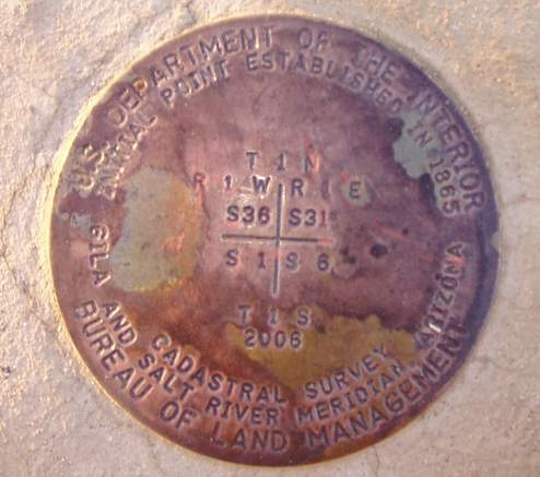 Close up of the "Initial Point" |
||||||||||||||||||||||||||||||||||||||||||||||||||||||
Apache County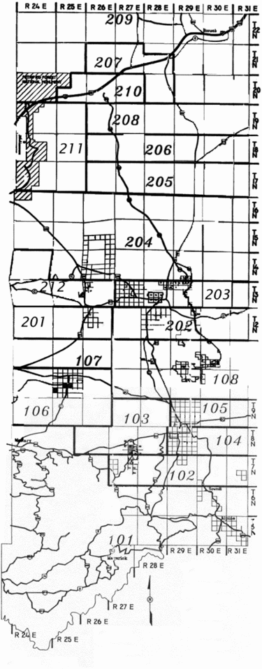 |
|||||||||||||||||||||||||||||||||||||||||||||||||||||||